
Geotrails in Australia highlighted by the Geological Society of Australia
AusIMM members may not be aware that around 80 geotrails have either been established or identified for future development around Australia as part of a national geotourism initiative.
This article describes several of these geotrails, and there may well be one near you. The inventory of geotrails around Australia is available on the website of the Geological Society of Australia (GSA), and information for each trail is often available for access by smartphone to use when visiting the geotrail.
As part of the work of the Geotourism Standing Committee of the GSA, each quarter an article, often describing new geotrails, is prepared by the Standing Committee and then submitted for publication in the GSA’s The Australian Geologist (TAG) magazine.
These articles also serve to brief GSA members about developments in the implementation of the National Geotourism Strategy (NGS) that is being implemented by the Australian Geoscience Council, of which AusIMM is a member. Whereas AusIMM participation is very much devoted to develop geotourism in regional mining communities with potential geoheritage and cultural heritage sites, GSA participation has focused on establishing a framework for creating and promoting high quality, sustainable geotrails.
Geotrails serve to deliver geotourism experiences through a journey linked by an area's geology and landscape as the basis for providing visitor engagement, learning and enjoyment. They relate directly to the tourism experience of a journey linking destinations and have widespread appeal, and are not perceived to compete with or impact on land management/access issues. Generally, geotrails are relatively easy to establish and represent a very cost effective means of enhancing regional development. They aim to meld the geological heritage features of a region with a cohesive story and endeavour to incorporate and package in the biodiversity and cultural components (including mining heritage) of the region through which the geotrail traverses.
A recent publication in TAG has focused on the Murchison GeoRegion of WA – Ancient Lands, Brilliant Skies. Through the Western Australia’s Mid-West Development Commission (MWDC) seven shire councils have established WA’s first major geotourism development on the Murchison GeoRegion of WA. Its ancient geology provides the ideal platform for unique, nature-based, tourism experiences of global significance, particularly to the ‘experience seeker / dedicated discoverer’ market. The GeoRegion’s self-drive trail, which traverses former mining areas, visits 21 sites of national/international, natural and cultural significance.
Another publication described the geology and landscape along the disused Railway Reserve Heritage Geotrail, in John Forrest National Park that is located on the Darling Scarp about 22 km east of Perth. There are many walking tracks within the national park, and maps are available online from the TrailsWA website showing these routes https://trailswa.com.au/trails/trail/john-forrest-np-railway-reserve-heritage-geotrail . The walk described in the article is now a heritage route, converted from the former main east–west train line, and is very popular for people using bikes and prams.
The Ku-ring-gai GeoRegion (KGR) project in the northern suburbs of Sydney has also been featured. This project is being driven by a Steering Committee that includes several past and present members of the Geotourism Standing Committee, and is one of the pilots of the NGS. The project team has identified several interesting geosites that have a cohesive geological/landscape story in places that were already known, easily and safely accessed, and frequently visited. It’s in a working partnership with the NSW National Parks and Wildlife Service and the three local government agencies (Hornsby, Ku-ring-gai and Northern Beaches). The project’s Geotrail Working Group is at an advanced stage in preparing geotrail guide notes (text and pictures) for the localities of Browns Field (Figure 1), and Long Reef with others in the pipeline.
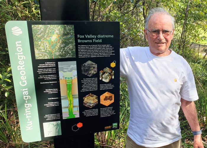
Figure 1. Browns Field Geosite sign with KGR Committee Member John Martyn
Another article is titled “Follow in the Footsteps of Giants - Outback Queensland Dinosaur Geotrails”, A formative geotrail offers a range of unique experiences not available anywhere else Australia. This geotrail links the towns of Winton, Hughenden, and Richmond and is the home to some of the world’s best preserved dinosaur fossils.
An article covering Tasmania’s North West Coast is the Wonders of the Wynyard Geotrail. It’s Tasmania’s newest geotrail and has been developed by the Wynyard – Waratah Council along the north-west coast in the vicinity of the township of Wynyard. This area has been the subject of prolonged geological interest with local highlights including an extinct volcanic centre at Table Cape and world class coastal exposures of fossiliferous shallow marine Tertiary sediments – first identified in 1840 by the renowned geologist/explorer Sir Paul Strzelecki - and underlying Carboniferous glacial tillites and rhythmites. The trail consists of nine established interpretative sites, each with its own geotrail signage, ample parking, and good accessibility.
In the last issue of TAG there is an article on the Glen Innes Highlands GeoRegion that lies within the Glen Innes Severn Local Government Area within the New England Region of northern NSW. It’s a region rich in natural and cultural heritage, boasting major landforms, waterways, vegetation, wildlife, and cultural heritage. It aims to become a model geotourism destination in line with the aspirations of the NGS. It has incorporated local First Nations peoples, state government agencies, the local council and other interest groups are working together to develop geotrails. It connects the Region’s, Australian Standing Stones monument, a new ‘Skywalk’ attraction, local mining heritage sites, World Heritage national parks, museums, festivals, and events.
It is hoped that in future years, the implementation of the National Geotourism Strategy will see the emergence of geotrails in areas of resources industry interest such as the proposed Bulga-Broke Discovery Trail in the Hunter Valley, and within the proposed Victorian Goldfields World Heritage Area https://goldfieldsworldheritage.com.au/, and the Esperance Goldfields area of Western Australia. These projects, as they evolve, will continue to be reported through TAG and the AusIMM Bulletin.