AI in Geoscience replacing multiple costly programs
Researchers are putting AI-enabled technologies like image processing, smart sensors, and intelligent inversion to the test in a number of geosciences areas. These technologies have the potential to aid the transition from qualitative to quantitative analysis. A Google search for AI in geosciences finds many references, including the open access journal “Artificial Intelligence in Geoscience” that provides for technical papers and discussion. Artificial Intelligence in Geosciences | Journal | ScienceDirect.com by Elsevier.
Many geoscience conferences in Australia also provide platforms for papers and discussion. For example; The Geological Society of South Australia (GSSA)’s Discovery Day and Western Gawler workshop, concluded that while AI and machine learning are changing some games, you still need an expert in the room.
The Australian Institute of Geoscientists is holding a conference on the 24th July in West Perth (on line & face to face) titled “AI in Geoscience”. See / register https://lnkd.in/gYJb-reZ this site also provides further links to up coming events. Using QGIS in Mineral Exploration (Online and On-Demand) | Australian Institute of Geoscientists (aig.org.au)
Linked In and other social media also provide a window into the contemporary use of AI, for example:
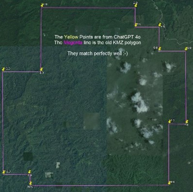
A recent LinkedIn post by a mining engineer found that transforming monotonous erroneous recurring tasks with ChatGTP4o to be a game changer. He found the ChatGPT4o seamlessly created a KMZ file of coordinates which were opened in Google Earth. What was impressive is that the entire exercise took just 20 seconds without using a single piece of software! Usually, this work consists of several steps, such as:
- Converting the image to ASCII (sometimes using OCR, which needs a license)
- Opening any GIS software
- Importing the ASCII data
- Selecting projection methods/Datum/etc (The software sometimes is smart enough to choose this for you)
- Converting to KMZ
- Exporting the KMZ
This shows how AI can revolutionise workflows, saving time and reducing errors in data handling tasks. The precision and efficiency of ChatGPT-4 can greatly enhance productivity and accuracy in various fields.
Another LinkedIn post also enlightens us with his time consuming and complex element determination for thin sections.
Essentially, Principal Component Analyses decorrelates the pixel information by transforming their values into a rotated coordinate system. This process enhances the subtle differences between minerals that are not easily discernible to the naked eye. When three of the new transformed axes are displayed as red, green, and blue channels, it produces a false colour image that allows geologists to differentiate objects. While understanding this process with a nine-channel dataset is difficult, it becomes easier to understand using a three-channel dataset, such as a photograph.
These days you don't need any programming skills to achieve this. You only need access to ChatGPT, which can write you a python script to accomplish this task.
- QGIS is an open-source GIS program for the display and analysis of GIS data It is now a valuable tool for the mineral exploration industry, and a viable alternative to the commercially available GIS packages. See; QGIS in Mineral Exploration — QGIS in Mineral Exploration 1.1 documentation (qgis-in-mineral-exploration.readthedocs.io)
Please share with us your geoscience experiences using AI and ChatGPT4o at geoscience@ausimm.com