Geoscience Society: Recommended books and further reading
Please see below a collection of books and other reading material that may be of interest to Geoscience Society members.
'Ground Support Technology for Highly Stressed Excavations' by Professor Ernesto Villaescusa has of the WA School of Mines Rock Mechanics Group.
The book quantifies the dynamic energy dissipation capabilities of commercially available rock bolt, cable bolt, mesh support and shotcrete systems. This is important for safer construction procedures at a number of deep underground mine sites. The book is presented in a logical structure of chapters and written in a style with undergraduate and postgraduate students, mine engineers and consultants in mind for self-learning and reference.
The book can be found here.
“The art and Science of Resource Estimation” by Jacqui Coombes.
These books are a guide for people and teams to make mineral resource estimation more accessible to a wider audience.
This book can be found here.
“Isotopes in Economic Geology, Metallogenesis and Exploration” by Springer. Isotopic mapping is revolutionising the search for new mineral deposits and has been an essential component in unravelling mineral systems. Now an overview of the topic is available online for free just as the world needs to increase mineral discovery rates and unravel critical mineral systems. Congratulations to all the authors and especially David Huston from Geoscience Australia and Jens Gutzmer from Helmholtz Institute Freiberg for Resource Technology (HIF) at HZDR for pulling it together!
This book can be found here.
Open report from the Mareano-Informar-Maremap-Geoscience Australia (MIM-GA) Marine Geomorphology Group
This report was developed by:
- Geoscience Australia
- University College Cork
- British Geological Survey
- Geological Survey of Norway
- Geological Survey of Ireland
- Latrobe University.
The report can be found at here.
This document describes and illustrates a geomorphic lexicon for the full range of coastal to deep ocean geomorphic Settings and related Processes that drive the formation, modification and preservation of geomorphic features on the seabed. This internationally developed scheme provides a consistent approach to classifying complex seabed data that can be easily understood and used by non-experts.
Maps of seabed geomorphology derived from bathymetry data provide foundational information that is used to support the sustainable use of the marine environment across a range of activities that contribute to the Blue Economy, including the sustainable management of Australia’s rapidly growing ocean economy.
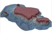
Figure of seamount and platform features of North Flinders Reef (Coral Sea Marine Park).